| Learning from the seminar of the new seismology | ||||||||||
| A Japanese atlantis story, sinking of uryu Island | ||||||||||
 |
||||||||||
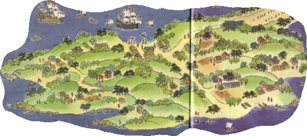
| There is the following introduction article in the magazine Newton (1991 Vol.11 NO.9). Uryu Island went down to Beppu bay in one day by the earthquake though it prospered as a port town of the early European ship in the Warring States period. |
||||||||||
| The name of the town of Minamihonmati, Nakahonmati and Kitauramati is on the old map. According to the book of 「Houhukikigaki」, the process of sinking is the next.
It faced the sea of Hunai, and Uryu Island was the large port filled with the ship of each place in Japan day and night. This island was in 3.5km from the town of Hunai, and it was in the north 2.2km of present Ooita City Jyukugou-cho. A big earthquake happened in the various countries at after 2 p.m. in Keichou 1 year (1596) July 12. It stopped after a short time though land split and a mountain collapsed. The people ran away in all directions, and it took shelter in the fields and mountains because the rumbling of the sea began when an inhabitant was relieved. The people who were afraid of the drowning of the town of Hunai gathered in the town of Seika on the hill. The water of the well of the village dried up at this time suddenly. Violent waves like a mountain swelled on the surface of the sea after a short time, and it reached to the town. |
||||||||||
 |
||||||||||
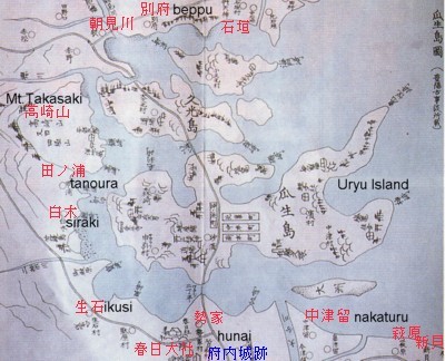
| Uryu Island old map. This was drawn in "the Houyou old thing talk" of the last days of the Tokugawa Shogunate term. The name of the village and a shrine name in the present map as well with a name in the inside of the figure were shown by red. A considerable name is left. Hunai is a name with the castle. A castle is said as the Hunai castle.
There is the next description in "the seismic story" of the Hamano Kazuhiko professor. "Uryu Island consisted of 2 islands, and there was a village of 12, and the person who went over 1000 lived in it." .It seems that this story is the very expensive thing of the reliability. Two islands are probably Uryu Island and Hisamitu Island. It seems that many uninhabited islands disappeared besides that to the sea. Because an island is in the present Beppu bay by no more than one. From Seika-mura, to Uryu Island, by the ferryboat, 270m. It is 870m from Uryu Island to Hisamitu Island by the ferryboat. There is no entry in the Beppu direction from Hisamitu Island. But, it is land continuation on another map. It is connected in a sandbar like Amanohasidate of even the figure which showed it first. When it is judged from the above, the total of two islands is a very big area. It becomes the island shadow of at least Noto Island which floats in the Nanao bay. |
||||||||||
|
Hunai and a village in the neighborhood were full of the seawater, and houses were washed away. For six hours rest, after water pulled it, many houses of Hunai collapsed, and the number didn't become known with the person as for the animal's damage. Uryu Island disappeared without a trace. |
||||||||||
| The above is the process of sinking. Uryu Island disappeared in one day from the viewpoint of sudden change. An atlantis has been able to do like this, too. Well, the commentary that an island sank due to the liquefaction phenomenon is on the magazine Newton. Next, it is introduced. Reappearance : uryu Island sinking . It can think about the mechanism of Uryu Island sinking from the result of the investigation as follows. An island was in the coastal waters of 1k from the mouth of the Ooita River. That island was connected with the land in the sandbar. This is Yryu Island. As for this island's ground, the sand of the Ooita River accumulated. That is the quality of sand which contains much water. Beppu bay is suddenly deep from that neighborhood. It is the inclination which is suitable for causing a landslide. For about 400 years ago, an earthquake directly above type occured in Beppu bay. The liquefaction of the ground of the island begins with the earthquake and the tidal wave. The outline of the island begins to get blurred first. The whole ground of the island became a liquid at last, and collapsed along the submarine slope. Only a part of the sandbar and the island remained behind. The pillar of the tree was driven into the sandbar for some reasons at that time. But, a part of both the sandbar and the island was washed by a wave soon, too, and it disappeared. The above is the commentary of the Newton journal. Because it was discovered by the submarine investigation, the matter of the pillar of the tree was published. Connection between the sand grains comes off at the time of the earthquake, and sand becomes a liquid-shaped. This is a liquefaction phenomenon. The base of the island must have been a rock board. Even the base of the island will be never made from sand like a sand hill. This is only the easy reasoning which solves all with the liquefaction. Sinking cause reasoning by Ishida theory is the decompression of the magma chamber which occurs in the second step of the earthquake. See a library 11. |
||||||||||
| BACK | ||||||||||